CSP uses concepts from electronic circuit theory to identify and map critical tracts of land that can serve as “connective tissue” between existing protected areas.
The results of CSP’s Disappearing West analysis, published online earlier this year, identified where — and how fast — we are losing natural areas to human development. This work, which garnered international attention, posed a call to action for new conservation measures to prevent the further loss of biodiversity and ecological functions across the West, particularly in the face of rapid land cover and climate changes.
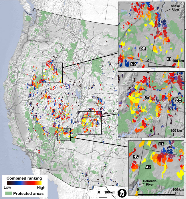
Now a new CSP study provides a tool for doing just this — in the most efficient way possible. Rather than targeting large areas for conservation efforts, which can be politically challenging, the study identifies relatively small tracts of land that would best connect habitat between existing protected areas (PAs). This “less is more” approach offers a more practical, optimized, and less costly solution for identifying and conserving public lands that are currently unprotected.
An innovative, quantitative approach
The study used high-resolution data from the Disappearing West project, which identified the level of human modification caused by multiple stressors such as urbanization, energy development, and transportation corridors. It also builds on a previous CSP investigation of unprotected, roadless Bureau of Land Management (BLM) lands in the West.
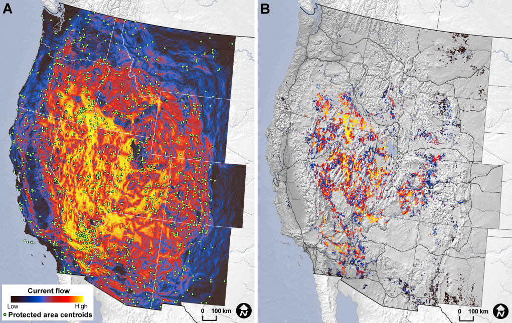
For this new analysis, CSP combined its model of human modification with a circuit-theory-based model of habitat connectivity to simulate patterns of “ecological flow” between existing PAs and across broad landscapes. Circuit models assume that ecological processes (such as individual movement and gene flow) are analogous to the flow of electrical current through a network of resistors. They calculate the potential current flow and voltage across a grid that represents a heterogeneous landscape characterized by differing resistance levels, depending on the amount of human modification. Although circuit theory has been used in ecology for about a decade, researchers typically model PAs as large, homogeneous patches with zero resistance to represent the condition of no human development. CSP, on the other hand, considered human modification, both within PAs and elsewhere, while also incorporating the likely effects of natural barriers such as steep slopes and rivers on the potential movement of plants and wildlife. The results of this analysis are not only far more realistic but they also facilitate in-depth comparison across management jurisdictions.
Another unique feature of this study is its large geographic scope; the connectivity model covers eleven western states in the U.S: Arizona, California, Colorado, Idaho, Montana, Nevada, New Mexico, Oregon, Utah, Washington, and Wyoming. In addition, the study results, provided as a series of highly detailed, open-source maps and data sets, are completely “species neutral” and can therefore be applied to future studies of all plants and wildlife.
Results and significance
In addition to revealing key connective lands between PAs, CSP’s model indicates three notable areas with high ecological flow: southern Oregon / Idaho, northern Arizona / central Utah, and much of Nevada, where the orientation of Basin and Range landforms appears to encourage flow between northwestern and southwestern states. Many of these areas lay within the BLM’s jurisdiction.
According to Brett Dickson, CSP’s President and Chief Scientist, the results of this study underscore the ecological value of BLM lands, which are often “underappreciated” by conservationists. These results may also have profound implications for nominating Areas of Critical Environmental Concern (ACECs) — special management areas designated by the BLM to protect, among other things, significant ecological resources. Determined through an administrative (rather than legislative or executive) process, ACECs may be nominated by any entity. CSP’s study provides critical information on connectivity that can support ACEC nominations, filling a key data gap for those involved in conservation efforts in the western U.S. The study results can also inform legislative or executive actions to expand Wilderness Areas, Wilderness Study Areas, National Monuments, National Conservation Areas, and other lands in the National Conservation Lands system.
To create maps and download data, visit Databasin.org. You will need to create an account and join the Ecological Connectivity in the West group.
This study was funded by the Pew Charitable Trusts. Read their web analysis here.
CSP collaborated with several leading experts for this project. Partners included Northern Arizona University, University of California ‐ Davis, The Nature Conservancy, and University of Wisconsin‐Stevens Point.