Our connectivity analysis found that the most vulnerable areas lie to the north and east of Phoenix and along interstate highways in the western portion of the state.
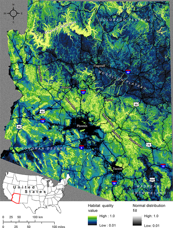
Meredith McClure (CSP), Brett Dickson (CSP), and Kerry Nicholson (Alaska Department of Fish and Game) recently published a study in Ecology and Evolution that examines the future of puma habitat and movement pathways in Arizona. Pumas are common in both northern Arizona, where they inhabit forests and other types of vegetation communities, and southern Arizona, where they tend to occupy more mountainous or rugged areas. Because pumas can move over long distances, their population connectivity is threatened by urbanized areas and roads, which form barriers to movement and migration.
With human populations expanding rapidly in Arizona, one of the fastest growing states in the U.S., creating structures for safe passage through or around human-modified landscapes is becoming increasingly important. A major goal of this study was to identify areas where such structures would be most beneficial.
The research team constructed several models for this analysis. GPS collar data had been collected from 28 pumas between August 2005 and March 2008 in the areas surrounding Payson, Prescott, and Tucson. This data was used to develop a habitat-quality model for puma movement. Circuit-theory models were then applied to estimate connectivity across the state and identify connectivity “pinch points” — or movement bottlenecks — where pumas are most likely to be impacted by future traffic and development. These pinch points present conservation opportunities for wildlife crossing structures or easements that could enhance connectivity and avert detrimental impacts.
Read “Modeling connectivity to identify current and future anthropogenic barriers to movement of large carnivores: A case study in the American Southwest” and view additional connectivity maps.